

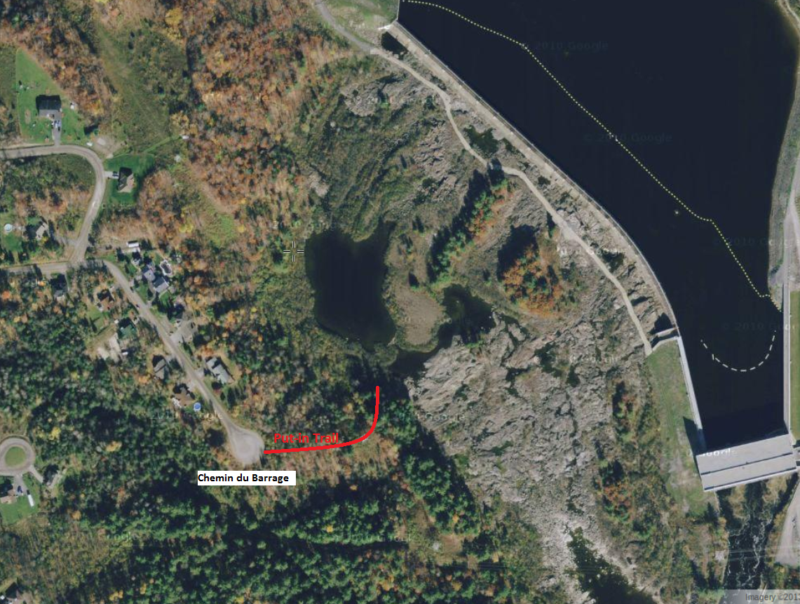
The hydro station's head is listed as 20.1 metres. I'm estimating that the drop directly at the weir is no more than 10m. After the weir the water drops 2-3m more into what I'm going to call Farmer's Pools. These pools allow for good access across the top of the multiple channels that follow. The pools can be seen below during a dry period and they are easily accessed from the end of Chemin du Barrage (a residential street; please drive easy along here). From the end of the road it is an easy hike down to the river-side. The first ~100m is along a good trail that takes one to and under a hydro tower. After that tower, turn to the left and head down the hill.
The video below begins by showing the put-in and the general conditions around the pools. Yes, there is a lot of weedish bush growing up in the water in places. The upper top right of the rapids from the weir down is currently a write-off due to this growth. After paddling across the pools I ended up scouting the drops below from a mid-river island. Before arriving at the river that day, I had been hoping to see a good line through the ledges below so that I could paddle it, but this proved difficult. The river was running a bit higher than during my previous outing, I was already a little bit injured, and I was padding solo. The potential holes tend to look much bigger to me when I actually have my boat with me. Thus, I retreated to my put-in location and then portaged the top meatier part of the rapids. After my portage, I still found myself running a bit of a sneak line around some of the heavier stuff. By the time I got out into the main current there wasn't much left to it. The lower part seemed a bit washed out at this level. I'm fairly optimistic that one could find good stuff in here at much reduced flows.
After Farmer's I ran the rest of what I'll call the Lower Gatineau. This took me by the smallish but nice looking waves at 'Poutine Bend' (there is a popular poutine restaurant on river-left here). After that I came to the rapids that are above Alonzo-Wright Bridge. Today these rapids are often referred to as Farmer's Rapids, but they are not the main Farmer's Rapids. There are a lot of serious holes on the left 3/4 of these rapids and I intentionally kept 20-30 feet off the far right shore. There is some opportunity to play along here; I was a bit too late in attempting to catch one great looking wave on the fly. Next time! Along with the very serious holes through here there are stories of concrete with rebar sticking out of it on the rivers bottom. Stay right!! One can scout this rapid fairly easily from both banks. There is a convenient take-out on the downstream side of the bridge on river-left. Or use the Timmies parking lot above the bridge.
Back up to Farmer's Rapids: Immediately after the base of the weir one generally finds the worse of the weed problems, and I did notice some man-made stuff along the river bed. But on the left side of the river there is at least one channel that appears to have a clean line down it. From the pool found in the next photo one should be able to find a nice line down.

The following video shows the rapids from a couple of other angles on a sunnier day. It also shows at the end the little bit that is left of Chelsea Rapids which are ~1 km above Farmer's.
With the high flows this June, the Lower Gatineau may make for some interesting after work paddling/exploring (without all the driving). Perhaps we can regain a chunk of this river for recreational purposes.
Link to photo album.
The two islands above Farmer's Pools allow for easy access to the upper sections of the rapids. Below the pools, both river-right and river-left have some issues due to bushes and deadfalls, but these could be cleaned up fairly quickly I believe. If a decent trail was created along either side a group might go out for several sessions on Farmer's before heading downriver to the take-out.
ReplyDeleteOr, one might decide to put-in along the river-left side below Farmer's Rapids and then paddle up to them. Hmmmmmm, options.....
I'm thinking that the rapids below the pools probaly should be considered a Class 4 (until demonstrated otherwise) at current levels. Lots and lots of serious holes! For a gauge I'm mostly using the info found here:
ReplyDeletehttp://ottawariver.ca/river-levels-flows.php
and then looking up what the level was for "Gatineau River at Maniwaki" the day before.